RNS:: Path2KMLSoftware author: Radoslaw Nowak (RNS::) | |||||||||||||||||||||||||||||||||||||||||||||||||||||||||||||||||||||||||||||||||||||||||||||||||||||||||||||||||||||||||||||||
|
|
|||||||||||||||
| |||||||||||||||
|
||||||||||
|
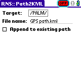
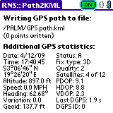
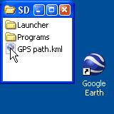
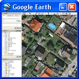
This freeware application will connect your PDA with a GPS receiver to collect location data from it. All coordinates (points) received from the GPS device will be saved to a file of your choice on a memory card. The path consisting of these points is saved in the KML format, which is easily readable e.g. by Google Earth. To open a KML file created with Path2KML, simply drag it onto Google Earth. As simple as that:
| ||||||||||
|
||||||||||
|
Keyhole Markup Language (KML) is an XML-based language schema for expressing geographic annotation and visualization on existing or future Web-based, two-dimensional maps and three-dimensional Earth browsers. KML was developed for use with Google Earth, which was originally named Keyhole Earth Viewer. The KML file specifies a set of features (placemarks, images, polygons, 3D models, textual descriptions, etc.) for display in Google Earth, Maps and Mobile, or any other 3D earth browser (geobrowser) implementing the KML encoding. From Wikipedia, the free encyclopedia. | ||||||||||
|
||||||||||
|
Path2KML supports any popular GPS receiver (the NMEA standard) and works on any Palm OS device with system version 3.5 or newer, and a memory card slot. | ||||||||||
|
||||||||||
|
| ||||||||||
Copyright © 2026 RNS::